Automatic registration of point clouds
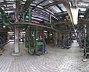
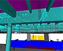
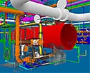
The automatic registration of laser scanning point clouds on basis of identical layers and points is effective, accurate and saves time. Individual scans only have a practical value if they are combined with each other. In order to match these individual scans with each other the neighbouring scans are mutually positioned in an automatic way and without targets. Afterwards all individual point clouds with a block adjustment (interlinked 3D transformation) are orientated in a combined coordinate system. The matching of each three pairwise not parallel layers in two scans is defining in each of these scans the same corner. The mutual orientation of these scans is thus possible.In two neighbouring scans there are not only three, but more than one hundred layers which can be used for the matching of identical layers over the overlapping areas. The layer search and the layer matching is mostly working automatically and is thus very efficient.
Because of the high redundancy and the extensive diffusion of identical layers, high precision and reliability can be reached.
The procedure consists of six steps:
1. Transfer of the scan data (point coordinates)
2. Automatic search for layers in the scans
3. Definition of neighbouring scans (scan pairs)
4. Matching of identical layers between two scans by
• Automatic matching or
• Manual matching as option
5. Block adjustment of all scans in one combined target system, either
• The local reference of one scan or
• A superior coordinate system with geodesic surveyed points
6. Delivery of reliable and exactly suitable registration parameters.
See www.technet-gmbh.de
back...