Basic Surveying with 3D Laser Scanning
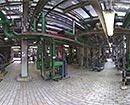
When doing a laser scanning project in most cases there will be more than one point cloud: The scanner is capturing all surrounding objects. This cannot be filtered which means that everything is captured what the scanner can "see " from its position.If objects are completely or partially hidden by other objects they will be captured from another position of the scanner. This results in having several scans in one project. From each of this individual scans a point cloud with its own coordinate system is created. Afterwards these point clouds are combined with each other by surveying methods. Finally all individual scans and thus all individual point clouds are referring to one universal coordinate system. An overall point cloud is created.
The coordinate reference can be the system of the respective country, a factory system or any other local system, e.g. a building axis system. The project-relevant coordinate system will be checked for accuracy (measured) and the capturing area will be densified. In detail this means: for being able to combine the individual scans with each other, so-called pass points are set and exactly measured in position and height in the capturing area of the individual scans.
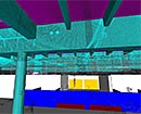
- Overall point cloud as LFM server database, e.g. as basis for external modelling or planning
- Leica Cyclone projects for the usage with different applications for the creation of intelligent 3D models, e.g. AutoCad or MicroStation with its additional products
- Registered individual scans for visualisation of the 3D point cloud, e.g. with NavisWorks
- ASCII data with RGB colour space for visualisation in special software, e.g. visualisation of the 3D point cloud with realicon – 4D communication
- Ortho images – sections or views of the point cloud as raster data in CAD drawings which are geo referenced and in correct position – this can help everybody in the project to get a quick overview of the situation in the according area
The pass points can be permanently marked (nails, bolts, target marks, etc.) or only be marked with targets for the duration of the surveying. In order to have a local coordinate reference further surveys for the system definition are necessary. For a building axis system e.g. the alignment of the building, the height reference and various pillars are surveyed. The basis for a high-quality data capturing by laser scanning is the net of surveying points which is determined with high precision for the coordinate reference. We are specialists for surveying and 3D laser scanning and thus are able to provide you this for 100%.
back...